
Durmitor National Park: Montenegro's Most Underrated Summit Destination
By Elias Thorne|Release date: May 4, 2026 |Reading time: 10–12 minutes
Author Background: Elias Thorne is an outdoor travel writer focusing on remote trekking routes, mountain communities, and long-distance hiking culture across Eastern Europe, Central Asia, and South America. His work centers on practical route analysis, seasonal conditions, and the realities of traveling in less-developed mountain regions rather than luxury tourism. He has spent years researching trekking infrastructure, trail logistics, and changing tourism patterns in destinations such as Albania, Montenegro, Oman, and Patagonia. His articles combine publicly available research, guidebook references, and field reports from hiking communities to help readers better understand remote routes before planning their own journeys.
If you've grown tired of crowded Alpine trekking corridors in the Dolomites or the Swiss Alps, Durmitor National Park offers a very different mountain experience.
Located in northwestern Montenegro near the border with Bosnia and Herzegovina, Durmitor is a high limestone massif shaped by glaciation, underground karst systems and dramatic canyon erosion.
According to UNESCO World Heritage documentation, the protected area contains:
48 peaks above 2,000 meters,
multiple glacial lakes,
extensive pine forests,
and part of the Tara River Canyon system.
【Official source: UNESCO World Heritage Centre — Durmitor National Park
https://whc.unesco.org/en/list/100】
The Tara River Canyon is frequently described in tourism literature as the deepest canyon in Europe, reaching approximately 1,300 meters in some sections.
【Source: Montenegro National Tourism Organization https://www.montenegro.travel/en】
Unlike heavily commercialized Alpine regions, Durmitor remains relatively undeveloped for international tourism.
You will not find:
extensive cable car systems,
densely spaced mountain huts,
or heavily managed summit traffic.
Instead, hiking here requires:
route awareness,
weather judgment,
navigation preparation,
and realistic physical conditioning.
That self-reliant atmosphere is precisely why many experienced hikers are increasingly interested in the region.
Žabljak: The Main Base for Hiking
Most visitors stay in Žabljak, a mountain town located at roughly 1,450 meters above sea level.
Several Balkan tourism and geographic sources describe Žabljak as one of the highest permanent urban settlements in the Balkans.
【Source: Montenegro National Parks / Municipal tourism materials https://npcg.me/en/parks/durmitor/】
Accommodation is mostly:
family-run guesthouses,
small mountain lodges,
apartments,
and seasonal campsites.
International hotel chains remain limited.
For hikers, Žabljak functions as:
the primary supply point,
the transport hub,
and the departure point for most major routes.
Practical note from field experience: Small supermarkets exist in town, but selection becomes limited for specialized trekking food. If you're planning multi-day hikes or high-calorie alpine days, buying supplies in Podgorica or Nikšić is often easier and cheaper.

Best Time to Visit Durmitor
Peak Hiking Season: Late June to Mid-August
This is the most stable weather window.
Typical daytime temperatures in hiking zones range from approximately 12°C to 22°C.
【Source: Meteostat climate averages for Žabljak region
https://meteostat.net/】
By late June:
most seasonal snow has melted from standard routes,
trail accessibility improves significantly,
and water sources are generally reliable.
However, this is also the busiest period around:
Black Lake (Crno Jezero),
Sedlo Pass,
and Bobotov Kuk.
Compared with the Alps, crowds remain modest — but parking and summit congestion still increase noticeably.
September: The Best Balance for Experienced Hikers
In practical terms, mid-to-late September is often the best compromise between:
trail conditions,
reduced crowds,
stable temperatures,
and autumn visibility.
Beech and larch forests begin changing color, while cooler morning temperatures frequently create low fog around the glacial lakes.
Trade-offs:
shorter daylight hours,
faster weather shifts,
and reduced reliability of minor springs.
Afternoon thunderstorms become more common.
May and Early June: Beautiful but More Serious
This period is underrated, but it is not ideal for inexperienced hikers.
Snowfields often remain on:
north-facing slopes,
ridge transitions,
and final summit sections.
The upper section of Bobotov Kuk may still contain:
snow patches,
ice,
and slippery limestone.
Depending on conditions, microspikes or crampons may become necessary.
Official conditions should be verified through:
local guides,
Žabljak tourist offices,
or Montenegro National Parks.
Weather: The Most Important Risk Factor
Durmitor's mountain microclimate changes rapidly.
Clear conditions can shift into:
fog,
hail,
thunderstorms,
or cold wind exposure within an hour.
Personal field observation: During a July ascent near the Bobotov Kuk ridge, visibility dropped below 10 meters after fast-moving fog entered the basin from the western slopes. Trail markers became difficult to identify almost immediately.
This is one reason GPS navigation or offline mapping should not be treated as optional on longer routes.
Recommended tools:
Maps.me
Gaia GPS
Organic Maps
Garmin GPS devices
Core Hiking Routes
Durmitor contains approximately 25 marked hiking routes according to Montenegro National Parks trail materials.
【Source: National Parks of Montenegro
https://npcg.me/en/parks/durmitor/】
Trail markings commonly use:
red circles with white centers,
red-and-white painted trail indicators,
and difficulty markers.
General difficulty convention:
Blue = easy
Red = moderate
Black = difficult
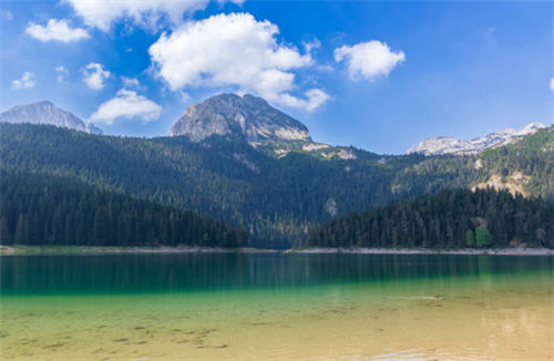
Black Lake Loop (Crno Jezero)
Overview
Distance: 3.5–4.6 km loop
Time: 1–2 hours
Difficulty: Easy
Elevation gain: Minimal
Black Lake is the park's most accessible and heavily visited natural landmark.
The lake sits at approximately 1,416 meters elevation.
【Source: Montenegro National Parks visitor information
https://npcg.me/en/parks/durmitor/】
The dark coloration comes largely from:
surrounding conifer reflections,
water depth,
and lighting conditions.
Trail surface:
compact dirt,
gravel,
roots,
occasional mud after rainfall.
Practical advice from field experience: Although technically easy, the gravel can become slippery after rain. Lightweight running shoes without grip are not ideal, especially for inexperienced hikers.
The area also functions as a major trail junction for:
Ice Cave (Ledena Pećina),
Bobotov Kuk approaches,
and several forest routes.
Bobotov Kuk (2,523 m)
Route Summary
Starting point: Sedlo Pass (~1,907 m)
Distance: ~10 km round trip
Typical duration: 5.5–7 hours
Elevation gain: ~730–940 m depending on GPS track
Difficulty: Difficult
Bobotov Kuk is widely recognized as one of Montenegro's best-known summit routes.
Elevation figures vary slightly depending on mapping methodology.
Cross-referenced sources:
AllTrails GPS tracks
Maps.me route data
Montenegro hiking guides
Parking and Start Time
Sedlo Pass is located along the P14 Durmitor Ring Road.
Parking capacity is limited during July and August.
Practical recommendation: Arriving before 8:00 a.m. significantly improves parking availability and reduces exposure to afternoon thunderstorms.
Route Breakdown
Stage 1: Sedlo Pass to Zeleni Vir
Terrain:
alpine meadow,
gravel trail,
rolling terrain.
This is the least demanding section physically.
Zeleni Vir functions as a useful early checkpoint.
Practical rule: If your pace, breathing or energy already feels problematic here, continuing upward usually becomes much harder later.
Stage 2: Zeleni Vir to Uvita Greda
This section introduces:
steeper climbing,
loose limestone scree,
and greater energy expenditure.
Technical exposure remains limited, but footing becomes less stable.
Trekking poles become especially useful during both ascent and descent.
Stage 3: Traverse Below Uvita Greda
This is psychologically more demanding.
The trail narrows in sections and traverses beneath exposed limestone slopes.
Rockfall risk exists.
Field observation: Loose stones can be triggered by hikers above. Maintaining spacing between groups is important.
Recommended precautions:
avoid stopping directly below climbers,
do not kick unstable rock,
wear a helmet if conditions are crowded.
Stage 4: Final Summit Section
The final section includes:
scrambling,
exposed rock,
fixed steel cables.
The cables function mainly as balance assistance rather than full Via Ferrata protection.
This section is not ideal for hikers with strong fear of heights.
During wet weather, limestone friction decreases sharply.
Descent risk is often underestimated.
Field experience: Descending loose scree while fatigued places significantly more stress on knees and ankles than the ascent itself.
Trekking poles are strongly recommended.
Summit Conditions
The summit platform is narrow and rocky with broad visibility across:
Durmitor massif,
Bosnia and Herzegovina,
and, in exceptionally clear conditions, distant Albanian ranges.
Visibility varies dramatically depending on atmospheric haze.
Afternoon fog formation is common.
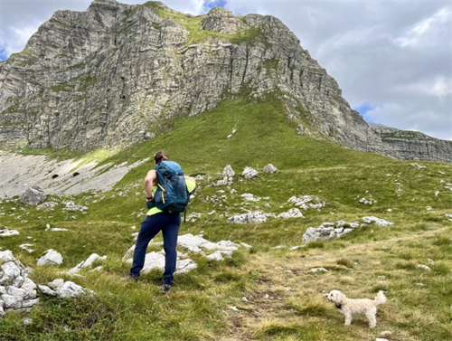
Mount Prutaš (2,393 m)
Overview
Route: Dobri Do approach
Distance: ~8 km round trip
Time: 4–5.5 hours
Elevation gain: ~700 m
Difficulty: Difficult but less technical than Bobotov Kuk
Prutaš is often recommended as the best alternative for hikers seeking:
panoramic scenery,
lower exposure,
and less technical climbing.
Its layered sedimentary appearance is one of the mountain's defining geological characteristics.
The southern approach from Dobri Do is generally safer and more stable than the western Todorov Do route.
Field observation: The summit plateau feels significantly calmer and less crowded than Bobotov Kuk, especially outside peak summer weekends.
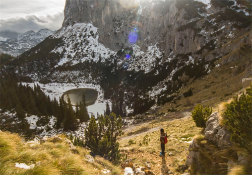
Škrčko Lakes Route
Overview
Distance: ~10.5 km round trip
Time: 6–7 hours
Elevation gain: ~840 m
Difficulty: Difficult
Veliko Škrčko and Malo Škrčko are high glacial lakes surrounded by steep limestone walls.
Compared with Bobotov Kuk, this area receives substantially fewer hikers.
Trail markings can become inconsistent in certain sections.
Water planning is critical.
Field experience: By late summer, smaller springs may weaken considerably. Carrying at least 3 liters per person is a safer baseline on warm days.
Ice Cave (Ledena Pećina)
Overview
Starting point: Black Lake
Distance: ~12.4 km round trip
Time: 5–8 hours
Difficulty: Difficult
Ice Cave remains partially frozen even during summer.
The route is substantially less beginner-friendly than many online travel articles suggest.
Key issues:
inconsistent markings,
route-finding difficulty,
scree exposure,
cable-assisted cave access.
Field experience: Poor route visibility can easily add extra hiking time if navigation errors occur.
Offline mapping is strongly recommended.
Park Fees and Regulations
Durmitor National Park charges entrance fees.
As of 2025–2026:
daily tickets generally range from €3–5,
multi-day passes are available seasonally.
【Official source: National Parks of Montenegro
https://npcg.me/en/parks/durmitor/】
Regulations may change.
Visitors should verify:
camping rules,
drone restrictions,
and vehicle access conditions before arrival.
Drone use is restricted in many protected zones.
Guided vs Independent Hiking
Experienced hikers with:
navigation skills,
mountain weather awareness,
and scrambling experience
can usually complete standard routes independently in good conditions.
Hiring a local guide is strongly recommended for:
unstable spring weather,
technical traverses,
first high-exposure hikes,
and Ice Cave attempts.
Typical guide pricing varies by:
route difficulty,
group size,
and season.
Estimated 2025–2026 range: €60–180.
Cross-reference sources:
local guide listings,
Montenegro tourism operators,
Viator/GetYourGuide regional averages.
Recommended Gear
Essential Equipment
High-ankle hiking boots
Trekking poles
Waterproof shell layer
Insulation layer
Sunglasses
High-SPF sunscreen
Offline maps
2.5–3 liters of water minimum
Recommended for Higher Routes
Basic first-aid kit
Headlamp
Emergency insulation layer
Helmet in rockfall zones
GPS communicator (Garmin inReach or similar)
Accommodation and Resupply
Žabljak remains the primary logistics base.
Available options include:
guesthouses,
apartments,
mountain lodges,
campsites.
Practical field note: The P14 Durmitor Ring Road contains extremely limited services.
There are effectively:
no major supermarkets,
no fuel stations,
and few emergency resupply points.
Fueling in Žabljak before entering the high plateau is strongly recommended.
Safety Considerations
Weather
Weather remains the single largest objective hazard.
Thunderstorms can form rapidly during summer afternoons.
Recommended practice:
begin early,
establish turnaround times,
descend immediately if visibility deteriorates.
Rockfall
Loose limestone is common on:
Bobotov Kuk,
sections of Prutaš,
and steeper scree traverses.
Avoid moving directly beneath other hikers.
Water Availability
Never assume seasonal springs will be flowing.
Late August and September may significantly reduce water reliability.
Wildlife
Bears and wolves exist within the wider region but encounters are uncommon.
A more realistic issue for hikers is interaction with livestock guardian dogs.
Recommended behavior:
avoid approaching sheep flocks,
remain calm,
keep distance,
allow shepherds to manage the dogs.
Communication
Cell coverage becomes inconsistent or nonexistent on higher routes.
Good practice includes:
informing someone of your route,
carrying offline maps,
and considering satellite communication devices.
FAQ
Is Bobotov Kuk suitable for children?
Generally not for young children.
Older teenagers with:
strong hiking experience,
comfort with exposure,
and proper supervision
may complete the route safely in stable conditions.
Can dogs complete the route?
The final technical section of Bobotov Kuk is not well suited for most dogs.
Turning around near Zeleni Vir is often the safer choice.
Are crampons necessary?
Usually not from late June through September.
However, snow and ice may persist during:
May,
early June,
and early October.
Always verify current conditions locally.
What is the best photography timing?
Morning light generally works best for:
Black Lake,
Savin Kuk viewpoints,
and lower valley photography.
Afternoon summit fog becomes more common later in the day.
Final Assessment
Durmitor National Park is not a polished Alpine tourism machine.
That is exactly why many experienced hikers find it memorable.
The combination of:
rugged limestone terrain,
lower visitor density,
self-reliant hiking culture,
and dramatic Balkan landscapes
creates an experience that feels increasingly rare in Europe.
But the mountain environment should not be underestimated.
Durmitor rewards:
preparation,
humility,
weather awareness,
and realistic decision-making.
Those qualities matter far more here than summit photos.
References
[1] UNESCO World Heritage Centre — Durmitor National Park
https://whc.unesco.org/en/list/100
[2] National Parks of Montenegro — Durmitor National Park
https://npcg.me/en/parks/durmitor/
[3] Montenegro National Tourism Organization
https://www.montenegro.travel/en
[4] Meteostat Climate Data — Žabljak Region
https://meteostat.net/
[5] Adriatic Ways — Durmitor National Park Guide (2026)
https://adriaticways.com/durmitor-national-park/
[6] Backpackers in the World — Bobotov Kuk Hiking Guide
https://backpackersintheworld.com/bobotov-kuk-hike-montenegro/
[7] The Road Reel — Bobotov Kuk Route Guide
https://www.theroadreel.com/bobotov-kuk-hike-montenegro/
[8] Moon & Honey Travel — Durmitor Hiking Trails
https://www.moonhoneytravel.com/europe/montenegro/durmitor-national-park-hiking/
[9] Life on the Roam — Durmitor Hiking Routes
https://lifeontheroam.com/hiking-durmitor-montenegro/
Disclaimer
This article is intended for informational and trip-planning purposes only.
Mountain environments involve objective risks including:
sudden weather changes,
rockfall,
route-finding errors,
slips and falls,
wildlife encounters,
and limited rescue access.
Route times, technical difficulty and trail conditions may vary significantly depending on:
season,
weather,
trail maintenance,
and individual fitness.
Before departure, verify:
weather forecasts,
official park regulations,
trail conditions,
and emergency information through Montenegro National Parks or local tourism authorities.
If you lack experience with:
exposed terrain,
scrambling,
alpine weather,
or remote navigation,
hire a qualified local mountain guide.
No article can replace on-site judgment and personal responsibility in the mountains.
Recommend for you:
Dientes de Navarino Circuit: A Wilderness Trek at the End of the World
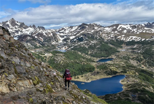
The route is a loop across the island’s jagged mountain spine. It measures roughly 53 to 54 kilometres, a figure confirmed by the official leaflet from Chile’s Ministry of National Assets and the independently produced Kanaska Maps project.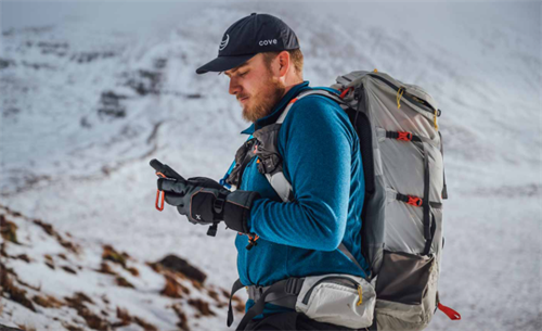
"Wearable Coach": Can a Smartwatch Really Replace a Mountain Guide?
You've probably noticed it. Over the last few years, the way outdoor watch brands talk about their stuff has changed. It used to be about tracking—distance, elevation, heart rate.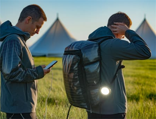
Solar Fabric Tents and Self-Heating Jackets: The Next Generation of Gear
Two ideas keep surfacing in hiking circles these days: tent fabric that generates electricity, and jackets that warm themselves up.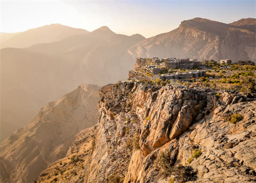
Trekking Oman's Hajar Mountains: Canyons and Ghost Villages
In northern Oman, under the shadow of limestone cliffs, there are stone villages where half the roofs have caved in. They don't show up on the main pages of most conventional guidebooks.