Lesotho: Trekking in the Kingdom of the Sky
————A hiker’s guide compiled from field reports and multiple sources — from the Drakensberg Escarpment to highland village trails
By Elias Thorne|Release date: May 8, 2026 | Reading time: ~14 minutes
Author Background: Elias Thorne is an outdoor travel writer focusing on remote trekking routes, mountain communities, and long-distance hiking culture across Eastern Europe, Central Asia, and South America. His work centers on practical route analysis, seasonal conditions, and the realities of traveling in less-developed mountain regions rather than luxury tourism. He has spent years researching trekking infrastructure, trail logistics, and changing tourism patterns in destinations such as Albania, Montenegro, Oman, and Patagonia. His articles combine publicly available research, guidebook references, and field reports from hiking communities to help readers better understand remote routes before planning their own journeys.
1. Why Lesotho: Geography and Distinction
Lesotho is often called the “Kingdom of the Sky.”
Its lowest point is around 1,400 m, making it the highest-altitude country in the world.【Britannica, Thabana Ntlenyana entry, 2025 revision】
But comparing it to the Andes or the Himalayas misses the mark.
Lesotho’s highlands are more like a lifted savannah on ancient basalt.
The terrain rolls gently for miles, then drops off into thousand-foot cliffs — the Drakensberg Escarpment.
For hikers used to the Rockies, the openness here can feel unsettling.
In the deep plateau, there are few trees or rock walls for reference.
Navigation depends on subtle shifts in contour lines.
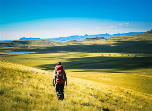
What draws people here is the mix of access and contrast.
From South Africa, Sani Pass puts you on the plateau at nearly 2,900 m.
From there, extended traverses unfold on grassland above 3,000 m.
But this gentle topography comes with a catch: you stay exposed to weather for long stretches.
Data from the South African Weather Service (SAWS) indicate that afternoon thunderstorms over the Lesotho highlands can build with alarming speed — often going from scattered cumulus to cloud-to-ground lightning in under an hour.【SAWS Lightning Detection Network data, cited in The Herald (South Africa), 11 April 2025】
Even during the popular November–December trekking window, the rule of “be over the pass by 10 a.m。” exists for a reason.
Numerous hikers have been caught out by sudden weather shifts.
2. Route Options: Beyond the Obvious
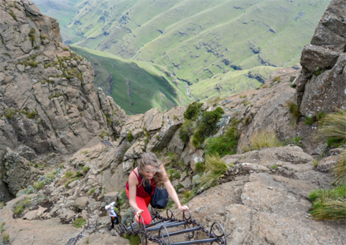
2.1 The Classic Objective: Sani Pass to Thabana Ntlenyana
Thabana Ntlenyana reaches 3,482 m — the highest point in southern Africa.【Britannica, “Thabana Ntlenyana,” 3,482 m / 11,424 ft】
The title attracts hikers, but understanding the walk matters more than the number.
From Sani Top (around 2,874 m), the round trip is roughly 24 km and typically takes 8 to 10 hours.
The terrain is not technical.
The route follows a dirt track to a telecommunications facility, then picks up a path marked by stone cairns to the summit.
One hiker on an online forum described it as “surprisingly easy, just long and very high。”
That is exactly where the risk sits.
Above 3,000 m, reduced oxygen can affect performance more than many people expect.
Symptoms of acute mountain sickness — headache, nausea, loss of appetite — are relatively common after rapid ascent to this altitude.
A lack of acclimatisation time is a widely recognised risk for people who travel from near sea level to the plateau in a single day.【Hackett & Roach, “High-Altitude Medicine,” New England Journal of Medicine, 2001, widely cited clinical framework】
Most commercial operators budget three days for this route, not two.
The extra day has practical value — for weather delays and for altitude adjustment.
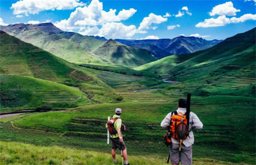
2.2 The Northern Circuit: Ts‘ehlanyane National Park to Bokong Nature Reserve
Ts’ehlanyane National Park protects one of Lesotho’s rare pockets of genuine forest.
Indigenous yellowwood trees survive here, and trails wind through bamboo stands and damp zones along the Hlotse River.
This is unusual for Lesotho: it is one of the few places where you can walk under real tree cover above 2,000 m.
The Waterfall Trail starts near Maliba Lodge at 2,030 m, covers approximately 8.7 km round trip, and tops out around 2,320 m.【DrakensbergHikes.com, “Waterfall Trail,” 2025 trail database】
The Litsumi Cave Trail involves more climbing: roughly 8.4 km out-and-back with around 590 m of gain, ending at a rock overhang above the Holomo Valley.【DrakensbergHikes.com, “Litsumi Cave Trail,” 2025 trail database】
A connecting route links Ts’ehlanyane with Bokong Nature Reserve along roughly 39 km of foot- and bridleway.【Humbo.com, “Tšehlanyane National Park,” 2025 park guide】
This is a multi-day traverse.
It demands offline navigation skills and self-sufficient logistics.
It is not suitable for hikers without solid route-finding experience.
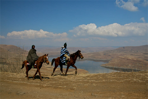
2.3 Pony Trails and Village Networks
An often-overlooked option is the network of mid- to long-distance routes through the community tourism system around Malealea.
These routes use the web of dirt paths that Basotho herders and farmers have travelled for centuries.
Typically, Basotho ponies carry the gear.
The community trusts are run by local coordinators and generally do not take bookings through overseas agencies.
From travel reports and guidebook accounts, this style is less a curated “experience” and more a temporary participation in a living land-use system.
At night, trekkers may sleep in a rondavel next to a cattle kraal.
One travel writer described the combination of smoke and cowhide smells in vivid detail — though comfort levels clearly vary.
The reliable way to arrange this is directly through Malealea Lodge or the local community trust, not through online middlemen.
3. Risks and How to Manage Them
3.1 Acclimatisation and Dehydration
The plateau gets intense sun, the air is dry, and the day–night temperature swing can exceed 20 °C.
Dehydration worsens AMS symptoms, but thirst is often blunted at altitude.
Current medical guidance suggests shifting from drinking when thirsty to a deliberate hydration rhythm — drinking at set intervals rather than waiting for the thirst signal.【Hackett & Roach, NEJM, 2001】
3.2 Thunderstorms and Lightning
The Lesotho–Drakensberg border region experiences some of the highest lightning-flash frequencies on the planet.
News reports indicate that the former Transkei, KwaZulu-Natal, and the Lesotho border zone record numerous lightning fatalities each year.【The Herald (South Africa), 11 April 2025 opinion piece citing SAWS data】
Injury can occur from a direct strike, ground current, or side-flash from nearby objects.
On the highveld, hearing thunder means you are already within range.
Consensus safety advice: move off ridges and summits, descend into a valley or depression.
Drop metal trekking poles and stay away from isolated tall trees.
If caught in the open, crouch with your feet together — do not lie flat — to reduce the path for ground current through the body.【Wilderness Medical Society practice guidelines, 2019 update】
3.3 Navigation Challenges
Trail markings across Lesotho’s highlands are often sparse.
Maintenance of signposted paths varies, even inside national parks.
Fog and dust whipped up by southwesterly winds can cut visibility and erase footprints quickly.
Loading offline maps onto a phone before departure is one of the most frequent recommendations from experienced visitors.
Carrying two different apps, such as Maps.me and OsmAnd, is often suggested.
Trail lines may be inaccurate or missing on a single platform in certain areas.
3.4 River Crossings
A thin blue contour on the map can turn into a thigh-deep channel of ice-cold water during the summer melt.
The Maletsunyane River is a well-known example.
In winter, its rocky bed can be crossed almost anywhere without difficulty.
From November to February, the same points may demand a careful judgement call.
Carrying lightweight wading shoes and keeping critical items in dry bags is a prudent step.
4. Gear List: Priority Adjustments for Lesotho’s Plateau
The following is not a full alpine kit list, but a set of adjustments specific to this environment:
Tent: A free-standing design is advisable. The inner tent needs a fine insect mesh — rain combined with livestock dung can attract large numbers of flies, even at campsites above 3,000 m.
Stove: In windy conditions, an integrated canister-top burner with a built-in windshield generally performs better than a remote-canister setup. White gas is fairly easy to buy in Maseru.
Jacket: It must be waterproof, but also capable of handling strong crosswinds. A hood with a stiffened brim helps keep rain out of the eyes in a blow.
Sleep system: Night temperatures can drop to around –10 °C, even in November. After sunrise, a tent can heat up fast — manage ventilation deliberately.
Navigation: Pre-load at least two offline map apps to cover gaps that may exist on a single platform.
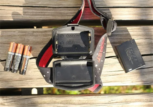
Communication: A Vodacom Lesotho prepaid SIM card generally has no signal above Sani Top. Anyone who relies on emergency communication should consider carrying a satellite device.
5. Permits, Entry, and Logistics
5.1 Visas
Since 10 June 2025, citizens of all EU member states can enter Lesotho visa-free for up to 14 days.【European Commission, visa reciprocity update, June 2025】
US citizens can stay for up to 90 days without a visa for tourism or business.【US Department of State, Lesotho country information, 2025】
Citizens of many other countries normally need to apply through Lesotho’s e Visa system — but as of late 2025 the e Visa portal is suspended.【VisaVerge.com, “Lesotho Visa Guide 2026,” last updated January 2026】
Applicants must now submit forms by email or through an embassy, and a processing buffer of at least four weeks is advised.【VisaVerge.com, “Lesotho Visa Guide 2026”】
A valid passport needs at least six months’ remaining validity and two blank pages.
5.2 Border Crossings
When entering Lesotho via Sani Pass from South Africa, the South African border post inspects vehicles.
This pass can close during bad weather, especially winter snow.
Hikers should confirm in advance how shuttle drivers charge for waiting time at the border, because delays can increase costs.
5.3 Park Permits and Fees
Park entry fees vary by park, residency status, and season.
For foreign adults, indicative ranges are roughly USD 10–100 per day.【AfricaTourVisa.com, “Lesotho National Parks: Fees & Rules,” 2025】
Some sites, such as Sehlabathebe National Park, require a high-clearance 4×4 to reach the park entrance.
On non-formal land, there is often no clear regulation — but it is strongly advisable to first obtain permission from the local chief.
This also provides basic local information and is a matter of respect.
5.4 Resupply and Money
Maseru is the last place with a reliable range of supplies before heading into the highlands.
Village shops typically stock maize meal and tinned goods; high-energy, lightweight trekking food is almost non-existent.
Credit cards are largely not accepted outside Maseru.
Carrying clean, uncrumpled US dollar notes — preferably new-issue bills — for exchange into maloti is recommended.
6. Low-Impact Practice and Community Relations
Encounters with shepherds and their flocks are part of walking across the plateau.
Multiple travel forums and trip reports mention requests for cash in exchange for permission to photograph people.
A more sustainable approach, suggested in guidebooks, is to carry school supplies or small compasses as alternative gifts.
Always ask the present guardian before offering anything.
Concerning water: streams above permanent human settlements in the Drakensberg have traditionally been considered drinkable.
However, water-quality studies point to a risk of Giardia and other waterborne pathogens below livestock watering points.
If boiling is not possible, a combination of a hollow-fibre membrane filter and a UV purifier pen covers different contaminant sizes.
Swimming in streams is generally regarded as acceptable, but using soap or toothpaste in them is strongly discouraged.
Such actions have drawn complaints from herders whose animals drink from the same water.
Do all washing at least 70 m from any water source.
FAQ
Q1: Is an armed escort necessary for trekking in Lesotho?
On the standard highland routes, generally no.
If you plan to enter remote, unsigned gorges close to the Lesotho–South Africa border, check the recent livestock-theft situation at a local police post and consider hiring a registered guide.
Q2: Can the “Roof of Africa Ultra Trail” race route be used as a trekking route?
The Lesotho Ultra Trail course is equipped with safety ropes on certain high-exposure sections during the race.
Outside the event, sections such as the Lehana’s Pass traverse involve rock sloping that carries fall risk.
It is suitable only for hikers with scrambling experience.
Q3: Is it possible to resupply between villages?
Usually not.
Village shops sell basics like maize meal and tinned goods, not lightweight trail food.
Maseru is your final resupply point.
Carry food for your entire route, plus one emergency day’s rations.
Q4: What is the most reliable method for water purification?
Boiling is the baseline, but fuel constraints often make boiling every litre impractical.
A recommended combination is a hollow-fibre membrane filter plus a UV purifier pen — the two methods work on different-sized pathogens and complement each other.
Q5: How should I respond to serious altitude sickness and descend safely?
The nearest medical help often involves hours of walking plus a motorcycle transfer.
Note the location of Motebang Hospital or the closest medical facility.
Agree with your guide in advance on the nearest airstrip or helicopter-accessible landing zone.
Evacuation costs are extremely high, so confirm your insurance covers helicopter rescue and medical repatriation.
References
[1] Britannica, The Editors of. “Thabana Ntlenyana.” Encyclopædia Britannica, most recently revised 2025. — confirms 3,482 m elevation for southern Africa’s highest peak.
[2] VisaVerge.com. “Lesotho Visa Guide 2026,” last updated January 2026. — notes the e Visa suspension and shift to email/embassy processing.
[3] The Herald (South Africa). “What to do when bolt from the heavens rains down,” 11 April 2025. — cites SAWS Lightning Detection Network data on high flash frequencies along the Lesotho border.
[4] DrakensbergHikes.com. “Waterfall Trail” and “Litsumi Cave Trail,” 2025 trail database. — provides distances (8.7 km and 8.4 km return) and elevation data (2,030 m to 2,320 m) for Ts‘ehlanyane NP.
[5] Humbo.com. “Tšehlanyane National Park,” 2025 park guide. — describes the 39 km connecting route to Bokong Nature Reserve and Cave Trail gain (590 m).
Disclaimer
This article is based on publicly available information current as of May 2026 and does not constitute a safety guarantee of any kind.
High-altitude mountain activities carry inherent risks, including but not limited to acute mountain sickness, hypothermia, lightning strike, and falls.
Route conditions, legal boundaries, and permit requirements can change at any time.
Verify the latest information through the Lesotho Tourism Development Corporation or licensed adventure operators before departure.
Readers must assess the feasibility of any itinerary according to their own experience, fitness, and qualifications, and accept full responsibility for their decisions.
Mention of any commercial entity, product, or service does not constitute an endorsement or recommendation.
Recommend for you:
Hiking Inspired by Space Tourism: Trekking Earth's Martian Landscapes
Commercial spaceflight has edged out of science fiction over the past few years. Space tourism is reshaping how people imagine faraway places.
Valbona–Theth Hiking Trail: Albania’s Most Scenic Single-Day Trek?
In the last few years, Albania’s “Accursed Mountains” have started showing up more often in hiking conversations.
Hiking the Accursed Mountains: A Complete Guide to Northern Albania
Online information about northern Albania’s Bjeshkët e Nemuna – often called the Accursed Mountains – tends to fall into two camps.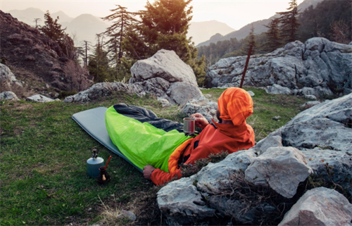
Emergency Bivvy Bags: Space Blankets vs. Ultralight Bivvies
Look at any hiking gear list and you'll see emergency shelter mentioned somewhere.And almost always, the conversation splits in two directions. On one side, the space blanket—so light you forget it's there, cheaper than a coffee.