Valbona–Theth Hiking Trail: Albania’s Most Scenic Single-Day Trek?
By Elias Thorne|Release date: May 9, 2026 | Reading time:~13 minutes
Author Background: Elias Thorne is an outdoor travel writer focusing on remote trekking routes, mountain communities, and long-distance hiking culture across Eastern Europe, Central Asia, and South America. His work centers on practical route analysis, seasonal conditions, and the realities of traveling in less-developed mountain regions rather than luxury tourism. He has spent years researching trekking infrastructure, trail logistics, and changing tourism patterns in destinations such as Albania, Montenegro, Oman, and Patagonia. His articles combine publicly available research, guidebook references, and field reports from hiking communities to help readers better understand remote routes before planning their own journeys.
In the last few years, Albania’s “Accursed Mountains” have started showing up more often in hiking conversations. Some travel guides now slot them into “Europe’s last wild spots.” Other posts warn that the roads are rough and some villages don’t even have an ATM.
A 2025 study by the German Agency for International Cooperation (GIZ) — titled “Peaks of the Balkans – How an Idea Got off the Ground,” published December 17, 2025, on the GIZ website — estimated that hiking tourism across the Balkans brings in approximately €25 million per year, with roughly €16 million staying in local communities. So yes, things are changing up there — but not to the point where the place has lost its character.
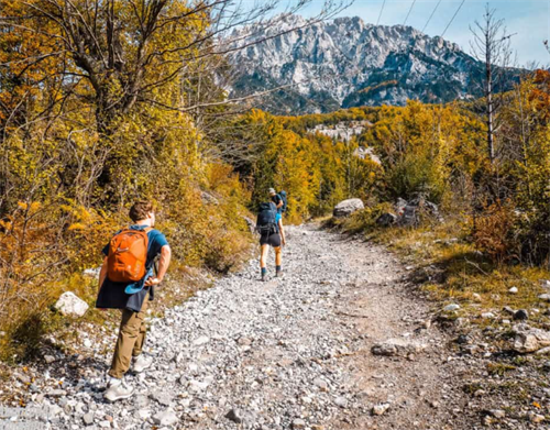
Sitting right in the middle of all this discussion is the Valbona–Theth trail, known locally as Valbona Pass. Is it long? It spans about 16 to 18 kilometers, with around 1,000 meters of elevation gain. Is it short? Not when you realize the whole trip takes at least three days — and that’s not because of the walking. It’s because there’s no direct road between the two villages. Every piece of gear and food needs to be sorted out in a town beforehand.
For hikers from Europe or North America who’ve already done a few classic routes, the real question isn’t whether the landscape is beautiful. It’s whether the time commitment and logistical hassle are worth it.
One trail, a handful of different numbers
Let’s start with the basic stats, because different sources don’t quite agree.
The Valbona–Theth direction is listed at 15.6 km with 965 m of elevation gain on the trail information page of the app AllTrails. The travel platform Trip.com, in its dedicated Valbona–Theth hiking guide, records it as approximately 16 km with roughly 800 m of ascent. Other comprehensive guides give 17 km and 1,000 m.
These differences shouldn’t be dismissed as errors. They most likely come down to where exactly in Valbona village people started their GPS recording. Some hikers begin tracking near the edge of the village; others start closer to the actual trailhead at the upper end. That alone can add or subtract a kilometer or two.
You’ll also see the trail referred to by different names online. “Valbona Pass,” “Theth Pass,” and the Albanian “Qafa e Valbonës” all point to exactly the same geographical feature: the saddle that separates the Valbona valley from the Theth valley. Knowing they’re interchangeable will save you confusion when you’re digging around for information.
Four sections, and what happens in each
The trail breaks down into four main sections.
Stage 1: Valbona village to the hillside cafés
Estimated time: roughly 1 to 1.5 hours.
The actual trailhead sits at the upper end of Valbona village. If you spent the night in the lower part of the village, just reaching the starting point can take nearly an hour — a detail many guides skip, but one that matters when you’re budgeting your energy for the day. The first stretch is fairly gentle, following the riverbed.
Between June and September, you might find one or two seasonal cafés open along the way, selling coffee and basic snacks. They’re fine for a quick stop, but don’t count on them as fixed resupply points. Off-season or in bad weather, they’re likely closed.
Stage 2: The climb to Valbona Pass
Estimated time: around 2.5 to 3.5 hours.
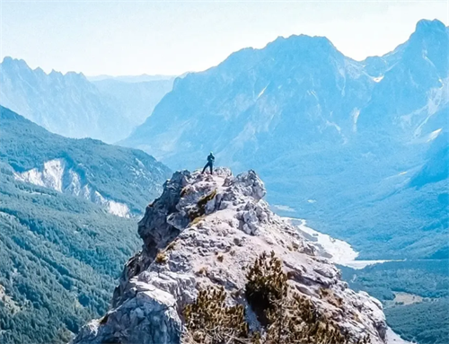
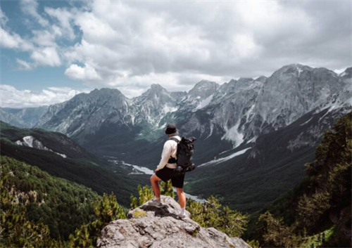
This is where the gradient gets serious. The lower section cuts through beech forest. In summer, the shade here makes it the most comfortable part of the entire trail. Above the tree line, the vegetation thins out fast. Limestone bedrock takes over, and the views open up all at once.
According to the detailed route description published by Zenith Travel in their guide “Theth to Valbona: The Ultimate Accursed Mountains Trek Guide” (last updated March 30, 2026), above the forest line you enter a classic karst alpine landscape — bare limestone, scattered juniper shrubs, and sweeping mountain panoramas with very little shelter.
The trail is marked with red-and-white paint blazes. Most of the way they’re easy enough to follow, but a few rocky sections can lead hikers off track. Having an offline map loaded on your phone beforehand is the safer approach. Apps like maps.me and Komoot both allow you to pre-download route data for this area, and they function without a mobile signal.
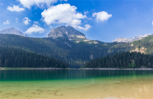
Stage 3: The pass itself
Valbona Pass isn’t a narrow notch; it’s a fairly open saddle. Official route data from the Peaks of the Balkans trail network, as referenced by Cicerone’s 2025 guidebook by Rudolf Abraham, puts the altitude at around 1,795 meters. On a clear day, you can look back toward the Valbona valley and forward over the ridgelines leading toward Theth.
In summer, a basic drink shack operates near the pass, selling coffee and cold drinks. It’s only there during peak season, though, and has no fixed opening hours. The Trip.com Valbona–Theth guide notes that even in mid-July, heavy rain can hit near the pass. At 1,800 meters, that may not sound extreme, but afternoon thunderstorms aren’t unusual. Most experienced hikers aim to reach the pass before midday.
Stage 4: The descent into Theth
Estimated time: approximately 2 to 2.5 hours.
This is the section that’s hardest on the knees. The roughly 1,100-meter drop is almost entirely on loose scree and limestone. When dry, the surface is already quite slippery; after rain, it becomes properly tricky.
A reviewer on AllTrails in October 2025 reported doing the reverse direction — Theth to Valbona — without trekking poles and ending up with knee pain they regretted the entire way. Poles are best treated as essential here, not optional. Footwear should be proper mid- or high-cut waterproof boots. Trail runners don’t give enough ankle support on that kind of surface.
Once you drop back into the beech forest, the Theth valley opens out in front of you. Usually the first thing you spot is the church spire on the far slope, then the scattered stone houses and guesthouse roofs on the valley floor. Time it right — say, after four in the afternoon, with the sun hitting the valley from the side — and it’s the kind of view that genuinely makes you stop and stand there for a while.
When to go: the differences between months matter
Most guidebooks give a window from mid-May to mid-October, but the quality within that window varies considerably.
July and August have the most reliable weather: clear skies, dry trails. The trade-off is the crowds. By “crowded,” we’re not talking Tour du Mont Blanc levels, but guesthouses fill up and ferry tickets get tight. Inside Balkan, in its guide “The Complete Guide to the Valbona to Theth Hike” (published February 15, 2026), specifically recommends booking Valbona and Theth accommodation in advance during these two months — the combined capacity of both villages is limited.
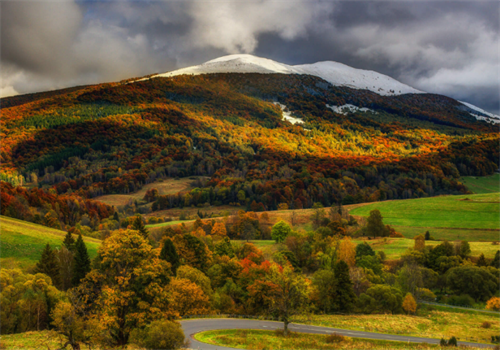
By mid-June, the snow is usually gone, and daylight hours are at their longest. You can set off at 6 a.m. and still finish in full light by 8 p.m. — no rush. September brings autumn temperatures, noticeably fewer people on the trail, and beech forests just beginning to change color. A World Nomads article by Gabriel Mungarrieta, published April 1, 2026, identifies June through September as the recommended hiking window.
October is a different story. In mid-October 2025, a hiker posted on the AllTrails platform that they completed the route in reverse under “perfect conditions — cloudless skies, no remaining snow.” That should be treated as a lucky exception, not the norm. After late September, early snowfall can close the pass with very little notice. If you’re planning for early October, you’ll need to check real-time conditions through a local guesthouse or hostel shortly before you go. A guidebook read months earlier won’t be reliable enough.
There’s also a practical detail often missed: there’s virtually no mobile signal anywhere on the trail. That means no mid-hike weather checks and no calling for help once you’re on the mountain. Check the forecast before you leave, and accept that from that point you’re on your own. It sounds obvious, but it catches out hikers accustomed to having a signal on trails.
Why the “three-day logic”
The thing that puzzles many first-time planners is how a 6-to-8-hour hike turns into a three-day commitment. The answer isn’t physical — it’s geographic. There’s no road linking Valbona and Theth directly. As the crow flies, the two villages are perhaps a dozen kilometers apart. By road, the detour is over 200 kilometers. Getting to the first village eats up a full day, and leaving the second one eats up another.
A typical three-day itinerary looks something like this:
Day 1: Leave Shkodra by minibus to Koman pier (about 2 hours), then take the ferry across Lake Koman (2.5 to 3 hours), then another minibus into Valbona (about 1 hour). Transport alone practically fills the whole day.
Day 2: Hike across Valbona Pass, arriving in Theth in the evening.
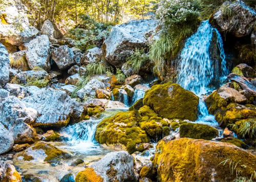
Day 3: Spend the morning exploring around Theth — Grunas Waterfall and the village’s blood feud tower are both within walking distance — then catch transport back to Shkodra after lunch.
Some people try starting from Tirana. A route guide published by the Adventures of LilNicki blog in November 2025 gives the total one-way cost from Tirana via the Koman ferry at about €28–30 per person. From Shkodra, it’s lower. Trip.com’s 2025 information provides a breakdown: Shkodra–Koman minibus around €8, Lake Koman ferry around €10, and Fierza–Valbona minibus around €8. Ferry packages can be booked at komanilakeferry.com. In high season, it’s wise to book early — tickets go faster than you’d think.
One more practical note: neither Valbona nor Theth has an ATM. No bank, no currency exchange. If you run out of cash up there, you’ll need to persuade someone to drive you back to a city — and nobody’s doing that for free. Withdraw enough Albanian lekë in Shkodra or Tirana before you leave, covering accommodation, meals, and return transport. Think of it as Step One of the whole trip.
Independent or a package? How to decide
There’s no right or wrong here. It’s more a question of where you prefer to put your effort.
Going truly independent means booking your own ferry tickets, negotiating with minibus drivers, and arranging your own guesthouses at both ends. The upside is full flexibility and the lowest cost. The catch is that public transport in the Balkans doesn’t operate on Swiss-style schedules. Timetables are more of a rough concept, and it’s not uncommon for drivers to speak only Albanian.
If you’d rather skip that, most backpacker hostels in Shkodra and Tirana sell self-guided packages. Note the “self-guided” part: on hiking day itself, you’re still walking on your own. No guide is leading the group. The package simply pre-books your transport and beds. In peak season, this is especially practical because hostels have established relationships with local transport operators and can cut through much of the communication hassle.
Guided trips — where a local guide walks the entire route with you — do exist, but they’re not the default choice. They tend to make more sense for off-season trips or for hikers who don’t feel confident navigating alone in the mountains. The cost is higher, but if it saves you from staring at your phone in thick fog on the pass and second-guessing every junction, that extra money may not be wasted.
Safety: let’s clear this up
In European and North American hiking forums, discussions about safety in northern Albania often bring up one term: blood feud. Yes, this was a real phenomenon, not an urban legend. The blood feud tower in Theth is physical evidence — built under the 15th-century Kanun customary code, it sheltered male family members caught up in a feud. Today the tower functions as a small open-air museum, with villagers holding the key. Atlas Obscura documents the structure in its entry “Lock-In Tower of Theth” (updated June 9, 2023).
What needs to be clarified is that blood feuds were an internal social mechanism of the local community. They never involved outsiders. According to safety data published by the travel risk information platform onmetravel.com on April 1, 2026, Albania’s current intentional homicide rate stands at 1.387 per 100,000 inhabitants — lower than both the United States and Turkey. The U.S. Department of State travel advisory for Albania is rated Level 2 (“Exercise Increased Caution”), the same level applied to France, Germany, Spain, and Italy.
For hikers, the safety issues that actually matter are much like those in Western European mountains: sudden weather changes, slippery scree, dehydration. Plus one extra — stray dogs.
It’s not uncommon for dogs to follow hikers along this trail. Most are friendly, sometimes trotting alongside for the whole route to Theth. But they remain semi-wild animals. Don’t feed them. Don’t approach them while they’re eating. Don’t shout suddenly near them. If you pass through grazing areas with shepherd dogs, the travel safety platform Cestee recommends locating the shepherd and walking close to him, so the dogs are less likely to perceive you as a threat.
So, is the trail worth it?
If you’re flying in from North America or Western Europe solely for this trek, honestly, it’s probably not worth it. Valbona Pass by itself can’t carry the weight of an entire transatlantic trip.
But if your larger plan already covers the Balkans or Southeastern Europe — maybe you’re working your way down from Dubrovnik, or connecting hiking routes between Tirana and Ohrid — then this crossing deserves a place near the heart of your itinerary.
That same GIZ study from December 2025 notes another figure: the Peaks of the Balkans trail network as a whole supports an estimated 1,380 full-time local jobs. What this means in practice is that a decent portion of what you spend — on a room, a bowl of stewed lamb, the cash handed to a guesthouse owner — stays in the local community rather than being extracted by hotel chains.
In a lot of European mountains that have already been smoothed and standardized, this kind of experience — loose gravel underfoot, family-run rooms, sharing a ferry deck with goats — isn’t the stuff of glossy memoirs. But it’s exactly the kind of thing that might make you sit on a guesthouse balcony in Theth with a glass of rough-but-effective raki and think: yeah, this was worth the hassle.
FAQ
Q: Is the reverse route (Theth to Valbona) harder?
A: Yes, it’s more demanding. That direction involves approximately 1,175 to 1,249 meters of ascent, roughly 200 to 300 meters more than the Valbona-to-Theth direction, according to GPS data shared on AllTrails. Arriving into the Valbona valley also doesn’t have quite the same visual impact as dropping into Theth with the church tower and stone houses laid out below.
Q: Can you do it in one day starting from Tirana?
A: No. Driving to Koman pier already takes 3.5 to 4 hours. The ferry adds another 2.5 hours, followed by a minibus transfer. Even if all connections run perfectly, getting from Tirana to Valbona fills an entire day. Adding a 6-to-8-hour hike is simply not feasible. And there’s no evening ferry back.
Q: Do experienced hikers need a guide?
A: No, during peak season the trail is clearly marked and busy enough that you’ll encounter other hikers regularly. This assumes you can use offline maps and navigate independently if fog or heavy rain reduces visibility to near zero. In May or October, when the trail is quieter and paint marks may be partially hidden by leftover snow, hiring a local guide is a reasonable safety choice.
Q: Are there really no ATMs?
A: Correct. Valbona and Theth have no ATMs, no banks, and no currency exchange services. Withdraw all the cash you need in Shkodra or Tirana before departure. Some guesthouses may accept euro notes, but don’t rely on this — the exchange rate offered will not be favorable.
Q: Can you take children?
A: If the children are 12 or older and have prior multi-day hiking experience, the route is feasible in summer. The steep, loose descent into Theth demands sustained focus and careful footwork, so it’s not recommended for children under 8.
References
[1] Gabriel Mungarrieta, “Hiking Albania’s Valbonë-Theth Trail,” World Nomads, April 1, 2026. https://www.worldnomads.com/explore/europe/albania/hiking-valbone-theth-trail
[2] Rudolf Abraham, The Peaks of the Balkans Trail: Montenegro, Albania and Kosovo, Cicerone, 2025. https://www.cicerone.co.uk/the-peaks-of-the-balkans-trail
[3] “Theth to Valbona: The Ultimate Accursed Mountains Trek Guide,” Zenith Travel, updated March 30, 2026. https://visitalbania.zenith.travel/blog/theth-to-valbona
[4] “The Complete Guide to the Valbona to Theth Hike,” Inside Balkan, February 15, 2026. https://insidebalkan.com/the-complete-guide-to-the-valbona-to-theth-hike/
[5] GIZ Albania, “Peaks of the Balkans – How an Idea Got off the Ground,” December 17, 2025. https://www.giz.de/en
[6] “Lock-In Tower of Theth,” Atlas Obscura, updated June 9, 2023. https://www.atlasobscura.com/places/defense-tower-of-theth-albania
[7] Onmetravel.com, Albania safety statistics, accessed April 2026.
Disclaimer
This article is based on publicly available travel guides, hiking community reviews, reports by governmental organizations, and industry publications as of May 2026. It does not represent the author’s personal field observations. Mountain weather, trail conditions, and local transport arrangements can change at short notice. Hiking and outdoor activities carry inherent risks. Readers should make their own assessments based on their fitness, experience, and the latest information obtained before departure. Mention of commercial services does not constitute a recommendation or endorsement. The author and publisher assume no liability for any loss or injury arising from the use of this information.
Recommend for you:
Bieszczady: Poland's Remote Eastern Wilderness
The Bieszczady Mountains sit at Poland's southeastern corner, bordering Slovakia and Ukraine.
First Hikers Using Starlink: What High-Speed Internet Does to the Wilderness Experience
In June 2024, SpaceX launched the Starlink Mini. It weighs 1.1 kg (2.43 lbs), according to SpaceX’s official specifications page, or 1.53 kg (3.37 lbs) with its 15-meter DC power cable and kickstand—and it fits in a backpack.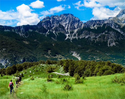
Hiking the Accursed Mountains: A Complete Guide to Northern Albania
Online information about northern Albania’s Bjeshkët e Nemuna – often called the Accursed Mountains – tends to fall into two camps.
Sweat-Powered Wearables: The Next Frontier in Off-Grid Charging
Few hikers talk about it, but one slow-burning frustration hits hardest on long trips: battery anxiety.